Solargis Data |
  
|
Solargis Data |
|
(Go to Importing Solargis hourly Data - go to Importing Solargis monthly Data))
Solargis s.r.o. http://Solargis.info/index.html provides
climate data for the study of Solar Energy systems in the form of
full historical time-series
and
TMY.
It provides namely solar radiation required for the simulation within PVsyst, from 01/1994/1999/2007 (depending on region) up to present, with a spatial resolution of approx 3km.:
·Global horizontal irradiance (GHI or GlobHor)
·Diffuse horizontal irradiance (DIFF or DiffHor)
·Air temperature (T): time coverage: 01/1991 up to present
·Direct normal irradiance (DNI or BeamHor) are also available for concentrating systems.
·Aerosol Optical Depth (AOD) - to be used in the future by PVSYST
·Precipitable water (pw) - to be used in the future by PVSYST
In the Solargis irradiance dataset, please note that :
·with hourly files ordered from climData: the effect of far shadings from mountains at sunrise and sunset is not included, unless explicitly requested, which means there in mountaneous regions an horizon mask must be applied in the project area of PVSyst.
·with Monthly files available from iMaps: the effect of far shadings from mountains at sunrise and sunset is included. It is not recommended to use those files for synthetic generation in mountaneous regions. Preferably the horizon mask should be added in PVSyst starting from horizon-free hourly files to ensure a correct transposition of diffuse onto the plane of array.
·with Monthly files available from pvPlanner: the effect of far shadings from mountains at sunrise and sunset is included. However, it can be removed in pvPlanners horizon editor by overwriting horizon data with value 0:0.
·the diffuse circumsolar radiation is included in the DHI
component (diffuse horizontal), which means that the data is
compatible
with the use of the Perez-transposition model.
The SolarGis data are available for pay.
Details of the Method (from
http://solargis.com/assets/doc/Solargis-database-description-and-accuracy.pdf)
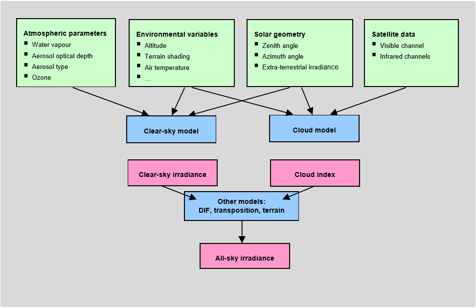
The solar radiation retrieval in Solargis is basically split into 5 steps :
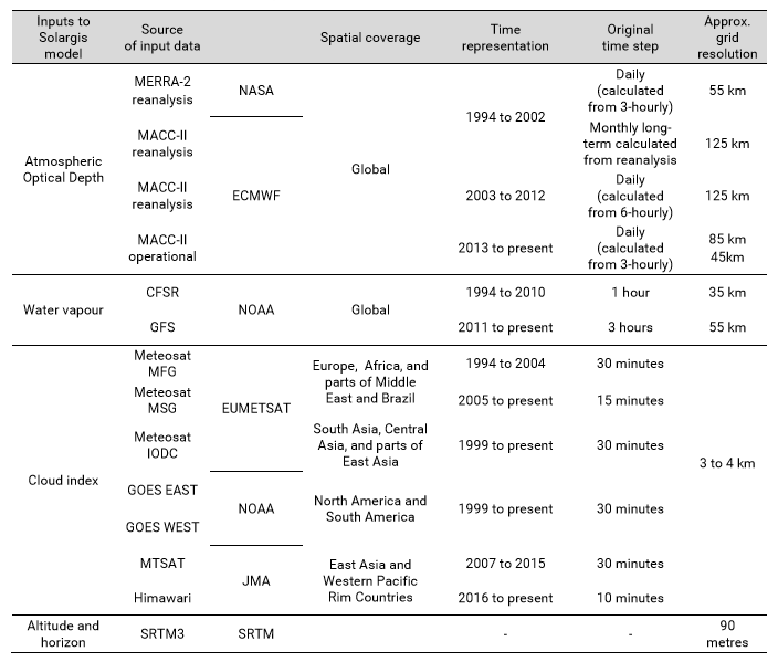
1.First, the clear-sky irradiance is calculated using the clear-sky model SOLIS, which needs Aerosols, water vapour and Ozone inputs
a.Aerosols are represented by Atmospheric Optical Depth (AOD), which is derived from the global MACCII database. The model uses daily variability of aerosols to simulate more precisely the instantaneous estimates of DNI and GHI. Use of daily values reduces uncertainty, especially in regions with variable and high atmospheric load of aerosols.
b.Water vapour is also highly variable, but compared to aerosols, it has lower impact on magnitude of DNI and GHI change. The daily data are derived from CFSR and GFS databases for the whole historical period up to the present time.
c.Ozone
has
negligible influence on broadband solar radiation and in the model
it is considered as a constant value.
2.Second,
the
satellite data are used to quantify the attenuation effect
of clouds
by
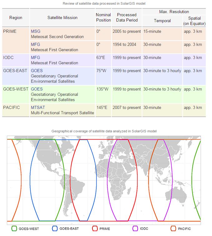
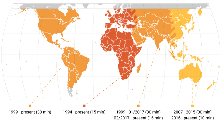
means of cloud index calculation. The data elaboration uses the
best available data sources (METEOSAT
©
EUMETSAT, ERA Interim © ECMWF), NCEP GFC and CFS
(Information
about
GOES satellites,
information about
MTSAT satellites. Read
also PVSyst main page on
satellites.)
The
Cloud model estimates cloud attenuation on global irradiance. Data
from meteorological geostationary satellites are used to calculate
a cloud index that relates radiance of the Earths surface,
recorded by the satellite in several spectral channels with the
cloud optical transmittance. A number of improvements are
introduced to better cope with complex identification of albedo in
tropical variable cloudiness, complex terrain, at presence of snow
and ice, etc. Other support data are also used in the model, e.g.
altitude and air temperature.
3.Third, the
clear-sky irradiance is coupled with cloud index to retrieve Global
Horizontal Irradiance (GHI) (all-sky
irradiance).
4.Fourth, the other solar irradiance components - direct, diffuse - are calculated From GHI:
a.Direct Normal Irradiance (DNI) is calculated by modified Dirindex model.
b.Diffuse horizontal
irradiance is derived from GHI and
DNI.
5.Last,
irradiance may be
further corrected for shading
effects from terrain. The
model for simulation of terrain effects (elevation and shading) is
based on the SRTM3
elevation data.
Model by Ruiz Arias is used to achieve enhanced spatial
representation from the resolution of satellite (3 to 4 km) to
the resolution of digital terrain model. Considering the shading
from terrain, the spatial resolution of data products is enhanced
up to 3 arc-seconds (which is about 90 metres at the equator, less
towards the poles). Direct, circumsolar and isotropic diffuse
components are
corrected for terrain shadowing.
For
full historical time series or TMY hourly files ordered via
Solargis climData, the shading is by
default not applied. It can be applied
if explicitely requested by users.
For
longterm monthly
averages aggregated data
ordered via Solargis iMaps, the shading is
applied.
The
horizon
in
Solargis can be edited and copied into a text file from the
tool
pvPlanner.
All Inputs to Solargis Model are summarised here.