NREL's Solar Resource for India - Discontinued |
  
|
NREL's Solar Resource for India - Discontinued |
|
----- This source of hourly solar data is not available anymore, only the maps are still available. For hourly data for india, refer to the NREL NSRDB viewer ------
The service provides hourly solar data and maps for India (to be respectively downloaded
here (dead link) and here) for the 2002-2011 time period
coverage.
Data covers useful information for PVSyst:
·Global horizontal irradiance (GHI or GlobHor)
·Diffuse horizontal irradiance (DiffHor)
·Wind Speed
·Temperature
Details of the Method (from http://www.nrel.gov/international/docs/readme_india_solar_maps.txt)
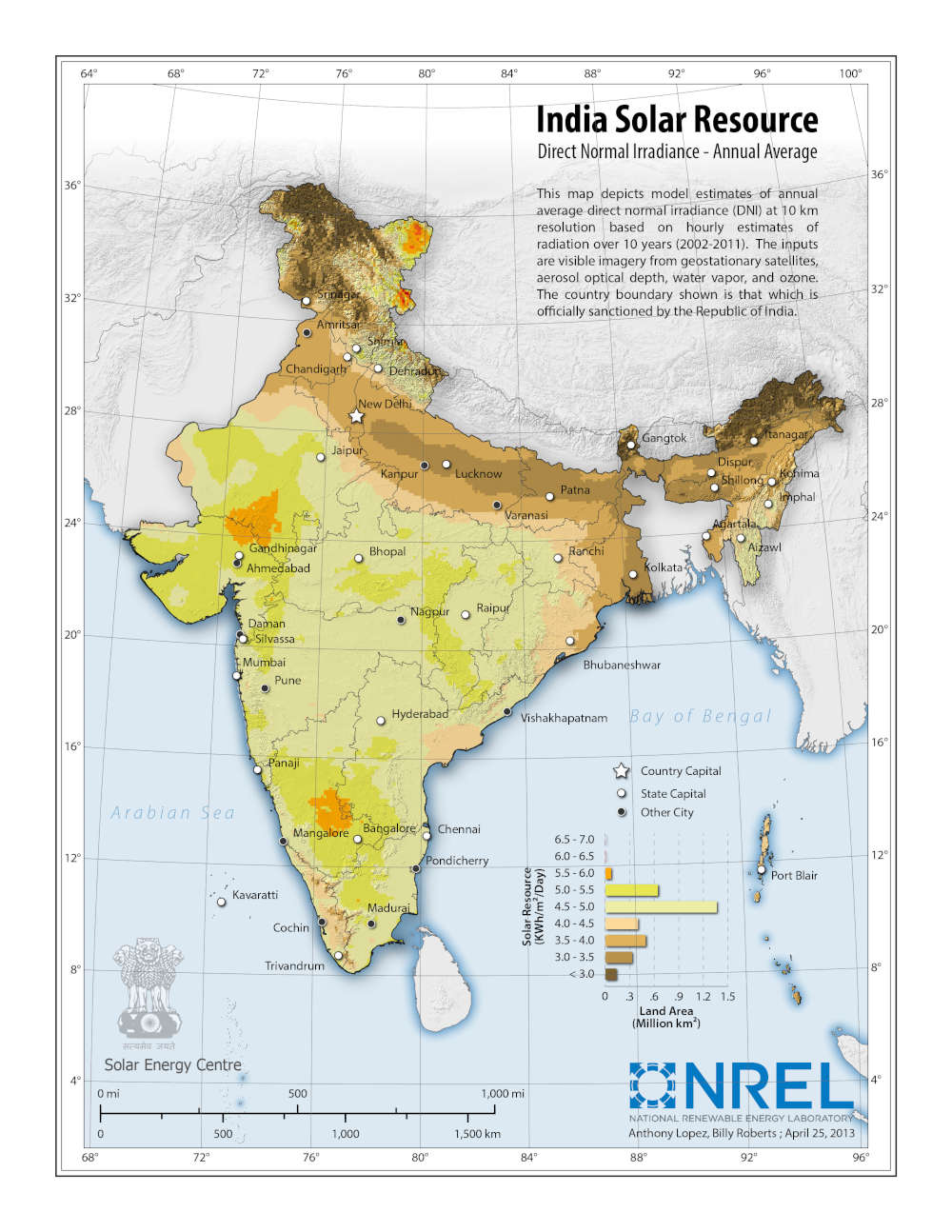
Maps cover all India at 10-km (0.1x0.1 degrees) spatial resolution.
The 10-km hourly solar resource data were developed using weather
satellite (METEOSAT)
measurements incorporated into a site-time specific solar modeling
approach developed at the U.S. State University of New York at
Albany.
The monthly and annual direct normal irradiance (DNI) and global
horizontal irradiance (GHI) maps were developed from hourly data
spanning January 2002 to June 2012 generated through application of
the SUNY satellite to irradiance model (1,2). A version of this
model was previously applied in the region using the European
Meteostat 5 and 7 satellites (3,4).
The recent application of the model to India included improvements
to the model's treatment of high reflectivity surfaces and an
update to the Aerosol Optical Depth (AOD) files used as input to
the model. A more in-depth investigation of monthly AOD data (and
their interannual variations) was undertaken because of their
strong impact on DNI and reports of elevated aerosol concentrations
across India from locally generated dust, long-range transport,
smoke from biomass burning and anthropogenic pollution.
Monthly gridded AOD values were developed for each month of the
SUNY model run for India. This approach was adopted based on
evidence of changing AOD over time in India (5-7). The gridded AOD
data set was developed using satellite data from MISR and MODIS.
These data sets were compared with ground-truth data from
NASA's Aeronet network, Indian Space Research Organization (ISRO)
data made available by the Solar Energy Center (SEC) of India's
Ministry for New and Renewable Energy and from additional sites
with data published in the literature. In the previous
release the mode of AOD values for each month were used as they
tend to be log-normally distributed. The current release uses the
mean AOD for the month as research indicates that regions with
higher aerosol loading are better represented by the mean. The data
set used for a given month was selected based on completeness of
satellite data and performance compared with available ground-truth
data. Improvements to the AOD data used as input to the radiative
model, and therefore subsequent improvements in solar resource
estimates, may be made in the future with increased availability of
ground measured aerosol data. Due to current modeling
limitations, various related atmospheric variables have not been
considered here, such as aerosol or gaseous absorption due to
elevated pollution in highly urbanized areas.
Comprehensive validation of SUNY model performance through
comparisons with ground-measured data have not yet been conducted
as no measured, quality-controlled data was available for analysis
at the time of this release. It is expected that comprehensive
ground measurements currently being taken by the Center for Wind
Energy Technology will soon be available for validation.
These products were developed by the U.S. National Renewable Energy Laboratory (NREL) in cooperation with India's Ministry of New and Renewable Energy, through funding from the U.S. Department of Energy and U.S. Department of State.
References :
1. Perez R., et al., A New Operational Satellite-to-Irradiance Model. Solar Energy. 73:307-317, 2002.
2. Perez R., et al., Producing satellite-derived irradiances in complex arid terrain. Solar Energy. 77:363-370, 2004.
3. Perez R., et al., Satellite Derived Resource Assessment in Afghanistan & Pakistan in support of the USAID South Asia Regional Initiative. NREL subcontract # AEJ65517201. 2007
4. Perez R., et al., Validation of the SUNY Satellite Model in a Meteosat Environment. Proc. ASES Annual Conference, Buffalo, New York, 2009.
5. Datar S.V., et al., Trends in background air pollution parameters over India. Atmos. Envir. 30: 3677-3682, 1996.
6. Porch W., et al., Trends in aerosol optical depth for cities in India. Atmos. Envir. 41: 7524-7532, 2007.
7. Ramanathan V., et al., Atmospheric brown clouds: Impacts on South Asian climate and hydrological cycle. Proc. Nat. Acad. Sci. 102: 5326-5333, 2005.